1. Start to Allotments
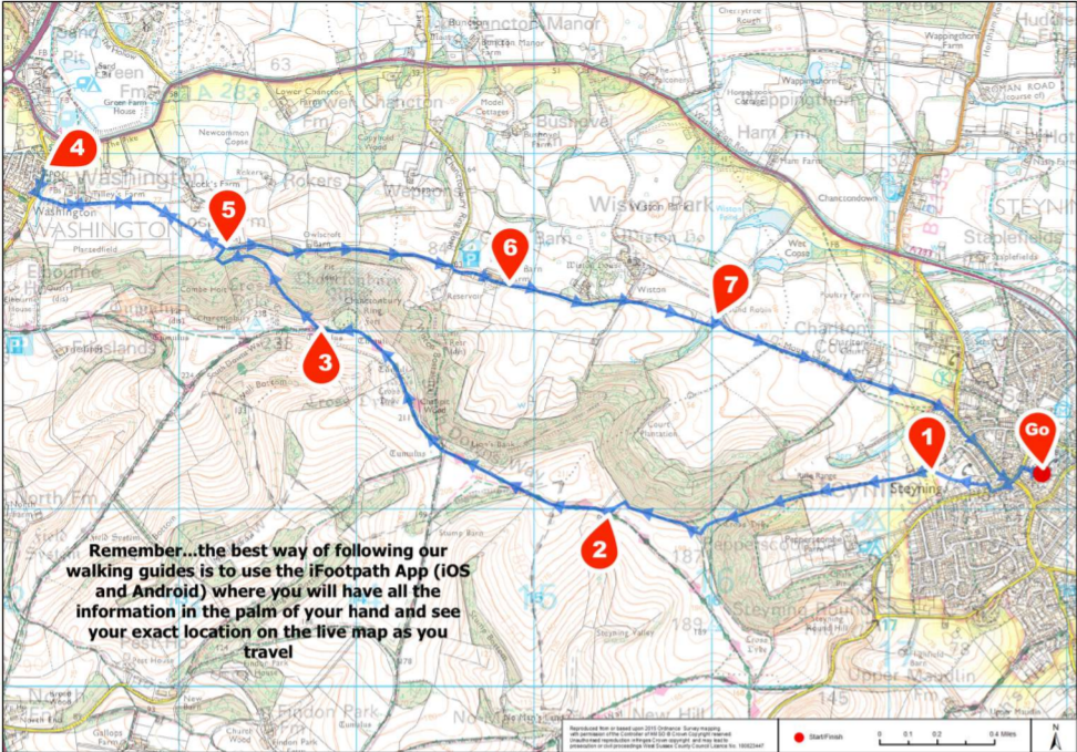
Standing with your back to the Steyning Centre and facing the car park, turn left along the tarmac path signed to Church Street, High Street and The Downs. At the T-junction with Church Street, cross over to the far pavement and turn left along this. Follow this pavement as it swings right by the mini roundabout, but only until the handrail on your left ends. At this point cross the road left to take the small side road opposite, Sheep Pen Lane, signed to the Police Station and The Downs.
Follow the main lane as it swings right and then take the first left which leads you past the police station on your right. Keep ahead to reach the parking area for the cricket club and Memorial Playing Field. Cross this playing field diagonally to reach the kissing gate in the far right-hand corner. Pass through this and turn left to join a stone track. This track leads you past a set of allotments on your left.
2. Allotments to South Downs Way
Follow the stone track leading you steadily uphill. Pass through the kissing gate and take the path ahead, still climbing. Pass through another old kissing gate and continue ahead on the same path. Soon you will come to the next kissing gate ahead.
NOTE: The next section of path crosses a section of chalk grassland, and you may come across a few Dexter Cattle grazing here so take care with dogs. Go through the gate and walk straight ahead following the grass path leading you uphill through the chalk grassland.
At the top of the grassland, go through the kissing gate ahead and follow the path continuing through a section of trees. Pass alongside the next kissing gate to reach a junction with a bridleway, marked with a fingerpost. Turn sharp right for just a few paces and then turn left to join the unsigned narrow path which continues leading you uphill through the trees (with the signed bridleway running parallel to your left).
Towards the top, the path swings right to reach a T-junction. Bear right along this stone path with a fenced field to your left. Follow this path as it leads you through a gentle dip and continues on, with the fence still running on your left. Eventually you will come to a way marker post, marking a fork. Turn left here on the grass bridleway which leads you between two fenced fields. Just beyond the brow of the rise you will come to a T-junction with a stone track, the South Downs Way.
3. South Downs Way to Chanctonbury Ring
Turn right along the South Downs Way. At the first fork in the track keep right, staying on the South Downs Way. Further along you will come to a fingerpost marking a crossroads of track. Keep straight ahead, signed as the South Downs Way. Further still, you will come to a cattle grid across the track. NOTE: You may come across sheep grazing from this point so take care with dogs. Pass through the gate to the right of the grid and keep straight ahead on the obvious stone track. Stay with this track which swings steadily left leading you to the hilltop woodland ring of Chanctonbury Ring.
4. Chanctonbury Ring to Frankland Arms
Keep ahead along the South Downs Way for only about 80 metres beyond Chanctonbury Ring (you will just need to guess this distance by pacing out 80 paces as there is no fingerpost). Turn right at this point, across the grass to reach a gate within the fence line. Pass through this wooden gate (with a blue bridleway arrow on the post) and join the grass path leading you fairly steeply downhill, with a fence running on your right.
Pass through another gate and continue downhill. Further along, the path leads you through a pretty section of dense woodland. Ignore the path which turns away sharp right, simply stay with the main woodland path which bears left and then undulates gently. Pass through a set of old wooden gate posts and then stay with the main path which swings right to reach an unmarked junction. Turn right and after just 35 metres you will come to a junction with a track (alongside a bridleway fingerpost).
Turn right along this track and, 50 metres later you will come to a wider section with four gates, two left and two ahead. Number the gates from left to right… one, two, three, four. Should you wish to omit the optional arm to The Frankland Arms, take Gate Four which leads you onto a woodland path, then skip to the directions in the section called ‘Four Gates to Great Barn Farm’. Otherwise, take Gate Two, a wooden gate that leads you into the farm field. (You may come across livestock in some of these fields).
Standing with your back to the gate, walk at about 10 o’clock on the diagonal path through the field. At the far side, pass through the gate and continue in the same direction across a second field to reach a stile. Cross this to enter a third field and continue in the same direction. As you reach the field boundary you will find a stone vehicle track, turn left along this (with the hedgerow running on your right). In the corner go through the gate ahead to enter a fourth field. Go ahead on the track which follows the hedgerow on your right. Halfway along this fourth field, ignore the stile on your right, instead keep ahead to reach the stile in the far right-hand corner.
Cross this and follow the narrow enclosed path ahead. Follow the wooden steps down through the trees and cross the sleeper bridge at the bottom. Follow the path ahead and you will emerge out alongside an old stile directly onto the road. Cross with care to the far pavement and turn right along this. This pavement will lead you directly to The Frankland Arms in Washington, ideal for mid-walk refreshments.
5. Frankland Arms to Four Gates
When you have finished at the pub, retrace your steps back along the pavement to leave the village and then turn left to re-join the footpath from which you emerged. Follow this path back across the sleeper bridge, up the steps and across the stile to enter the first field.
Keep straight ahead along the left-hand edge of the first and second fields. Part way along this second field, you will come to a way marker post on your left. Fork right here, at about 1 o’clock, to reach a stile. Cross this and continue in this same direction across the third and fourth fields. Exit via the wooden gate to reach the junction with four gates that you passed through earlier. Take Gate Four, the second gate on your left, which leads you onto a woodland path.
6. Four Gates to Great Barn Farm
Follow this path ahead, along the edge of woodland, with fenced pastures on your left. Stay with this woodland path which climbs steadily and leads you between old gate posts. The path then descends, swinging left and then right to run along the left hand edge of a clearing. Pass through another old gateway to re-enter the woodland and continue ahead on the main track (which can get very muddy at times).
Towards the end of this track, pass alongside the metal gate and soon afterwards you will come to a junction of tracks. Turn right and then immediately left to reach the entrance gates for Great Barn Farm. Pass through these vehicle gates (or use the tall kissing gate alongside) to join the stone track ahead. This track leads you between the buildings of Great Barn Farm.
7. Great Barn Farm to Mouse Lane
Keep straight ahead, passing through the next metal gateway (or using the stile alongside). You will pass a pretty small timber barn on your left, sat on mushroom-shaped saddle stones, before passing between modern barns. Beyond the farm buildings, continue on the stone track which leads you between fields, with lines of trees and hedgerow each side.
Stay with this track for some distance, crossing two stiles along the way. Immediately after the second stile, you will see the private entrance drive for Wiston House on your left.
Do not take the private drive, instead keep straight ahead on the tarmac access lane which leads you under a pretty brick and iron footbridge. Where the main tarmac drive swings left, fork right onto a stone track between hedgerows.
Follow the fenced grass track as it doglegs left then right and leads you to the next stile. Cross this and continue along the path which follows the left-hand edge of a large crop field. Part way along this field, your path bears left across a grass meadow to reach a stile. Cross this and follow the path through the woodland belt, emerging out to another meadow at the far side. Bear left along the path and, as you reach the power lines overhead, bear left again into another small woodland belt. Follow the path through the woodland and you will emerge to a T-junction with a small tarmac access lane, Mouse Lane.
8. Mouse Lane to End
Turn right along the lane (this is a very quiet access road but do take care of occasional traffic). Follow Mouse Lane ahead for about 600 metres, passing a single property on your left to reach a crossroads. Keep straight ahead on the main access lane which leads you between steep woodland banks.
At the end of Mouse Lane you will come to a junction with Steyning High Street. Bear right to join the pavement along this, passing The Star Inn in your left and the fire station on your right. Simply continue ahead along the High Street and swap to the left-hand pavement at the zebra crossing. At the mini roundabout, follow the pavement as it swings left into Church Street and then turn right into School Lane which leads you directly back to the Steyning Centre where this walk began.


